3. Analysis of coastal spatial plans
<< The Integrated Coastal Zone Management (ICZM) for the Northern Coast of Central Java
Spatial plans in Indonesia are the product of the planning system in Indonesia which is mostly centralized and known for hierarchical planning. The system is inspired by a balanced development concept in the sense that national income will be distributed according to the central government strategic plan to promote equal distribution of socio-economic development throughout the nation. The legal basis for the system is the Law No. 26, 2007, Undang-Undang tentang Penataan Ruang (Law for the Republic of Indonesia on Spatial Planning).
This accommodates a spatial administrative allocation of geographical units based on resources endowment and functions such as protected area, cultivated area, rural and urbanized area. The spatial plan is used as a guideline for physical development, i.e. infrastructure, in urban and rural areas.
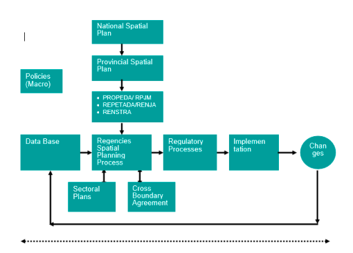
The hierarchical system starts at the National Spatial Plan (RTRN/Rencana Tata RuangNasional) as the top frame for the regional/provincial spatial plans). At the provincial level spatial planning works as frame for the lower level spatial plans, i.e. district/regency level and municipal level. In this system provincial/Regional Spatial Plan (RTRW/Rencana Tata Ruang Wilayah Propinsi) is a frame for the spatial plans of regencies and municipality (RTRW Kabupaten and RUTR Kota) within the province.
Amongst the planning instruments that the local agencies have spatial plans are considered the most comprehensive and popular because it aims to integrate all inter-boundary and inter-sectoral issues and land use demands for relevant sectoral development programs.
The planning process (see figure above) in the context of natural resources management requires a longer term planning view. It should be integrating sectoral developments (cross sectoral), taking into account natural resources and their natural interrelationship (cross-boundary management) and natural resources sustainability (natural resources accounting) as well as the involvement of all stakeholders affected by economic development activities and natural resources utilizations. This requires the following aspects:- Database of natural resources carrying capacity, the dynamic management of database that can be retrieved, improved and monitored (e.g. through the geographical infor- mation system), compatible to all sectors.
- Coordination, at all levels of the planning system (vertical integration), all sectors (hori- zontal integration), this includes all stages of the development management process (policy and institutional, planning, implementation and monitoring/evaluation)
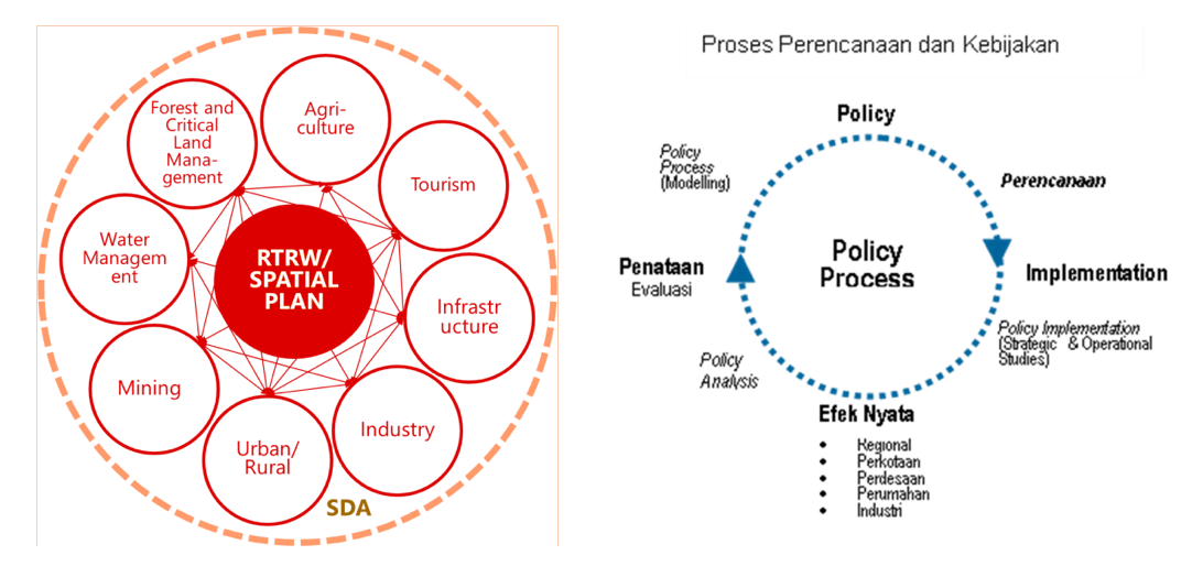
In spatial planning, all aspects should be intertwined considering both upstream and down- stream. In spatial planning in Indonesia, RTRW / Spatial Planning will plan, regulate and con- trol many elements that are not limited to the forest and protected area management, water management, agriculture, tourism, infrastructure, industry, urban and rural settlements, min- ing and security. All related aspects will go through the planning and policy process as a dy- namic system and provide feedback on all planned aspects.
The planning/policy process as a dynamic system (figure 5) consists of 4 main subjects, namely: Policy, implementation, the effects and evaluation
- initial policy that will affect planning
- planning that will provide direction for implementation including strategy
- implementation will have a real effect on all planned aspects
- real effects will provide input for policy improvement for structuring evaluation
- evaluation of the arrangement will result in a new policy
Acknowledgements
Victor Coenen (Witteveen+Bos), Susan Arts (TwynstraGudde, Jaap de Heer (TwynstraGudde), Mugy Grimwaldy (Bita Bina Semesta) and Henni Hendarti (Deltares), 30-9-2021
Final content report Integrated Coastal Zone Management for the Central Java Province


